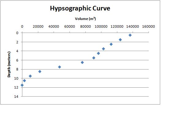
The term bathymetry is defined as the depth of water relative to sea level. Thus bathymetric measurements can determine the topography of the ocean floor, and have shown that the sea floor is varied, complex, and ever-changing, containing plains, canyons, active and extinct volcanoes, mountain ranges, and hot springs. Some features, such as mid-ocean ridges (where oceanic crust is constantly produced) and subduction zones, also called deep-sea trenches (where it is constantly destroyed), are unique to the ocean floor. Bathymetric maps also depict the contours of lakes. From these maps you can create a hypsographic curve, which we did for class. To figure out the total volume of the lake, just add up all the volumes of the different contours.
These are my hypsographic charts:
also for more info on bathymetric maps and hypsographic curves, check out:
http://www.waterencyclopedia.com/Oc-Po/Ocean-Floor-Bathymetry.html
http://lakewatch.ifas.ufl.edu/circpdffolder/Morph2ndEdPt2.pdf

No comments:
Post a Comment